Milwaukee to Port Washington
Between Milwaukee and Port Washington, there are several possible routes. I describe two of them here. |
|
|
Interurban Trail route.
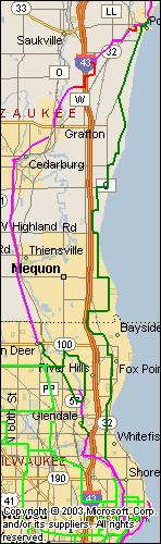
From the Milwaukee Art Museum, start on the bike trail that runs on the west side of Lincoln Memorial Drive. This trail follows the former Chicago and Northwestern railroad right of way that ran from Chicago to Minneapolis, and to Seattle. It has become part of Milwaukee County's Oak Leaf Trail system. (For a map of the Oak Leaf Trail, take this link.)
When the Oak Leaf Trail turns left into Estabrook Park, keep going north on the former right of way. On the Oak Leaf Trail map, this is called the Zip Line. Just before crossing Mill Rd, the trail switches to the right of way of a former Interurban.
North of Brown Deer Rd, the trail becomes the Brown Deer bike trail which extends north to the county line where it becomes the Ozaukee County Interurban Trail, which runs the length of Ozaukee County, with a few well-marked on-street sections. (For a map of the Ozaukee County section of the trail, see here.) This trail passes through Port Washington and into Sheboygan County, becoming the Sheboygan Interurban Trail.
Then proceed north on Santa Monica Boulevard through Whitefish Bay and Fox Point. Just after Santa Monica becomes Indian Creek Parkway and turns west, turn north on Regent Rd. Just before the railroad crossing, turn northwest on Santa Monica, then west on Fairy Chasm Rd, and north on Port Washington Rd (be careful: heavy traffic, no shoulder).
An alternative to the route described above is to take Lake Drive in Milwaukee County. This route more closely follows the lake shore but at the cost of possible heavy traffic on Lake Drive. However, Lake Drive is heavily used by bikes. Start by taking the bike trail that runs north on the lake (east) side of the Milwaukee Art Museum. Follow this trail on the east side of Lincoln Memorial Drive until it climbs the bluff and stops just short of the intersection with Lake Drive. Follow Lake Drive (Highway 32) north through Shorewood, Whitefish Bay, Fox Point, and into Bayside. Turn left on Fairy Chasm Rd. and north on Port Washington Rd, joining the first route.
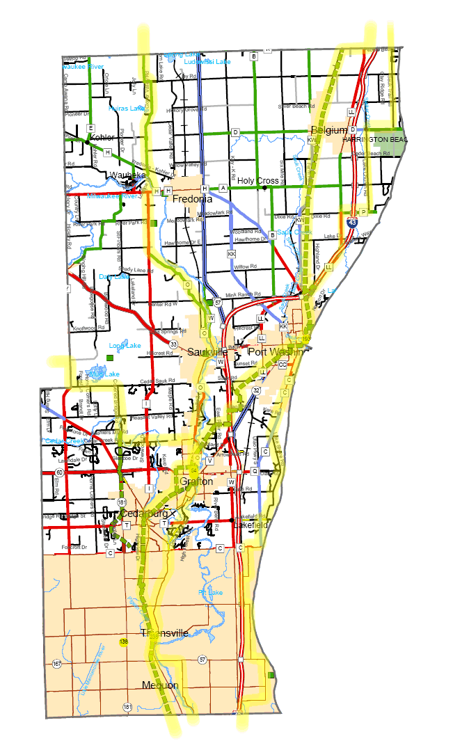
In Ozaukee County, follow this sequence: west on Zedlar Rd, north on Lake Shore Drive, east on Mequon Rd, north on Lake Shore Drive, west on Highland, north on Lake Shore, east on Bonniwell, north on Lake Shore, east on Pioneer, east on Lake Shore, east on Lakefield, north on Lake Shore Rd, north on County C which becomes Division in Pt. Washington. Turn east on Chestnut and north on Washington, joining the Interurban Trail route.
|
|
|
 |
|
|
|
|
|
|
|
|
|
|
 Milwaukee River Route Milwaukee River Route
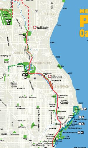
This route starts the same as the Interurban Trail route described above. However, shortly after the bridge over Capitol Drive, take a left into Estabrook Park (at the television transmission tower). Follow the Oak Leaf Trail (shown in light blue on Milwaukee County's Oak Leaf Trail map) north through this park and along the Milwaukee River, using various trails and parkways.
Where the trail crosses Green Tree Rd, turn right onto Green Tree (ignoring any sign that says to go straight). After crossing the Milwaukee River, turn left on N River Rd. When N River Rd ends at Dean Rd take a left until Dean ends at Range Line Rd. Go north (right) on Range Line (the Oak Leaf goes left) and then take a left on West Green Brook Rd until it ends at N Upper River Rd. Follow this road north until the county line, where it jogs left and continues north as N River Rd. Then go west (left) on Mequon Rd until it crosses the river and intersects the Interurban Trail. (Mequon Rd can be busy and has no shoulders; you may use its sidewalk, legally considered a multi-use trail.). After crossing the Milwaukee River, you will encounter the Interurban Trail.
To continue following the river, turn right from the trail onto Buntrock Rd, which quickly becomes Green Bay Rd. Green Bay Rd winds north until it re-encounters the Interurban Trail north of Grafton.
|
|
|
Lake shore route
There are a number of ways to stay closer to Lake Michigan than either of the routes described above. For example, from the art museum, one can take the trail on the east side of Lincoln Memorial Drive until it climbs the bluff and stops just short of the intersection with Lake Drive. Follow Lake Drive (Highway 32) north through Shorewood, Whitefish Bay, Fox Point, and into Bayside. Turn left (west) on Fairy Chasm and follow it to Port Washington Rd (route 32). This route more closely follows the lake shore but at the cost of possible heavy traffic on Lake Drive. However, Lake Drive is heavily used by bikes.
Alternatively, start on the Interurban Route described above. When the trail crosses Hampton Ave, switch to Santa Monica Boulevard. Then proceed north on Santa Monica Boulevard through Whitefish Bay and Fox Point. Just after Santa Monica becomes Indian Creek Parkway and turns west, turn north on Regent Rd. Just before the railroad crossing, turn northwest on Santa Monica, then west on Fairy Chasm Rd, and north on Port Washington Rd
Be careful on this section of Port Washington: it has heavy traffic and no shoulder.
The following roads will take you to Port Washington:
- North on Port Washington
- North (right) on Katherine Drive
- East on Zedlar Ln
- North on Lakeshore Dr
- West on Mequon Rd
- North on Lakeshore Dr
- West on Highland Rd
- North on Lakeshore Dr
- West on Bonniwel Rd
- North on Lakeshore Dr
- West on Pioneer Rd
- North on Lakeshore Dr
- West on Lakefield Rd
- North on Lakeshore Dr
- North on County C to Port Washington
|
|
Port Washington to Sheboygan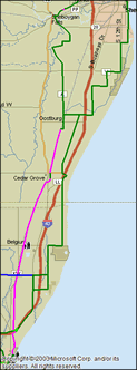
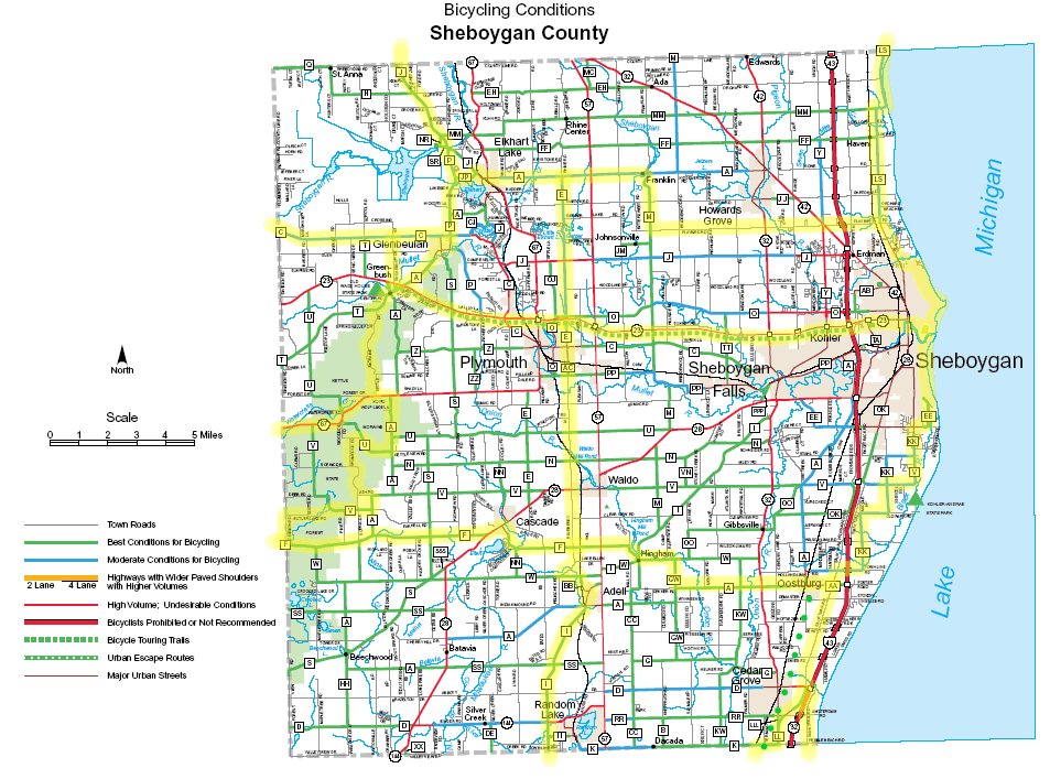
From Downtown Port Washington, take the Ozaukee and Sheboygan Interurban Trail (shown in purple at left) north to Oostburg in Sheboygan County. From the north end of Oostberg, go east on county KK (Town Line Rd.) and follow KK through various twists and turns into the southern edge of Sheboygan (12th St.).
(A variation is to continue on Old Park Rd which enters Kohler Andrae State Park at a former entrance now closed to cars, but open to bicycles and go north on the park road.) At Weeden Creek Rd, go east to Lakeshore Dr. Take Lakeshore north (becomes 7th Street in Sheboygan) to Indiana. Go west on Indiana, north on 8th, northeast on Lake Front, and east on Pennsylvania to Sheboygan's lake front bike path.
|
|
|
|
|
|
|
|
|
|
|
|
Downtown Sheboygan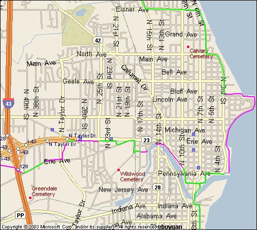
This map shows the route along the Sheboygan lake front. There is also a connector to the Old Plank Road Trail, which runs along highway 23 to Greenbush.
|
|
|
|
|
|
|
|
|
|
|
|
|
|
|
|
|
|
Sheboygan to Manitowoc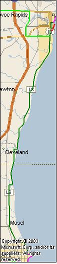
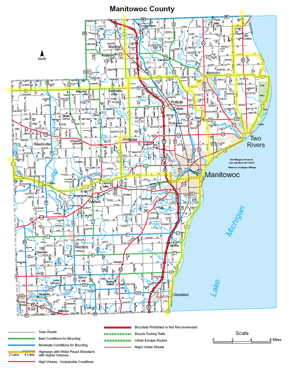
From downtown Sheboygan, follow the lake side bike path north until it climbs the bluff and ends. Go north on 3rd St., west on North Ave., north on 6th, west on Eisner Ave., and north on highway LS (15th St.). Follow LS all the way to Manitowoc, where it becomes 10th St. Go east on Columbus, north on 8th, and, after crossing the river, east on Maritime Drive to Lake Michigan. |
|
|
|
|
|
|
|
|
|
|
|
|
|
|
|
|
|
|
|
Manitowoc to Algoma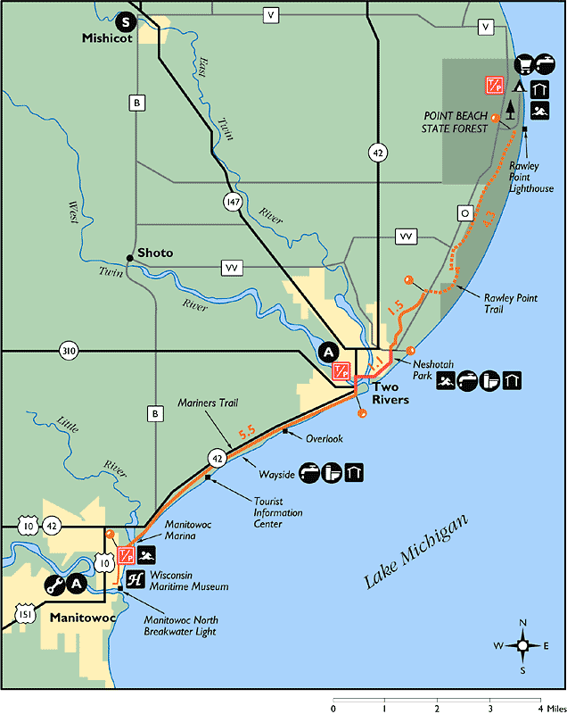
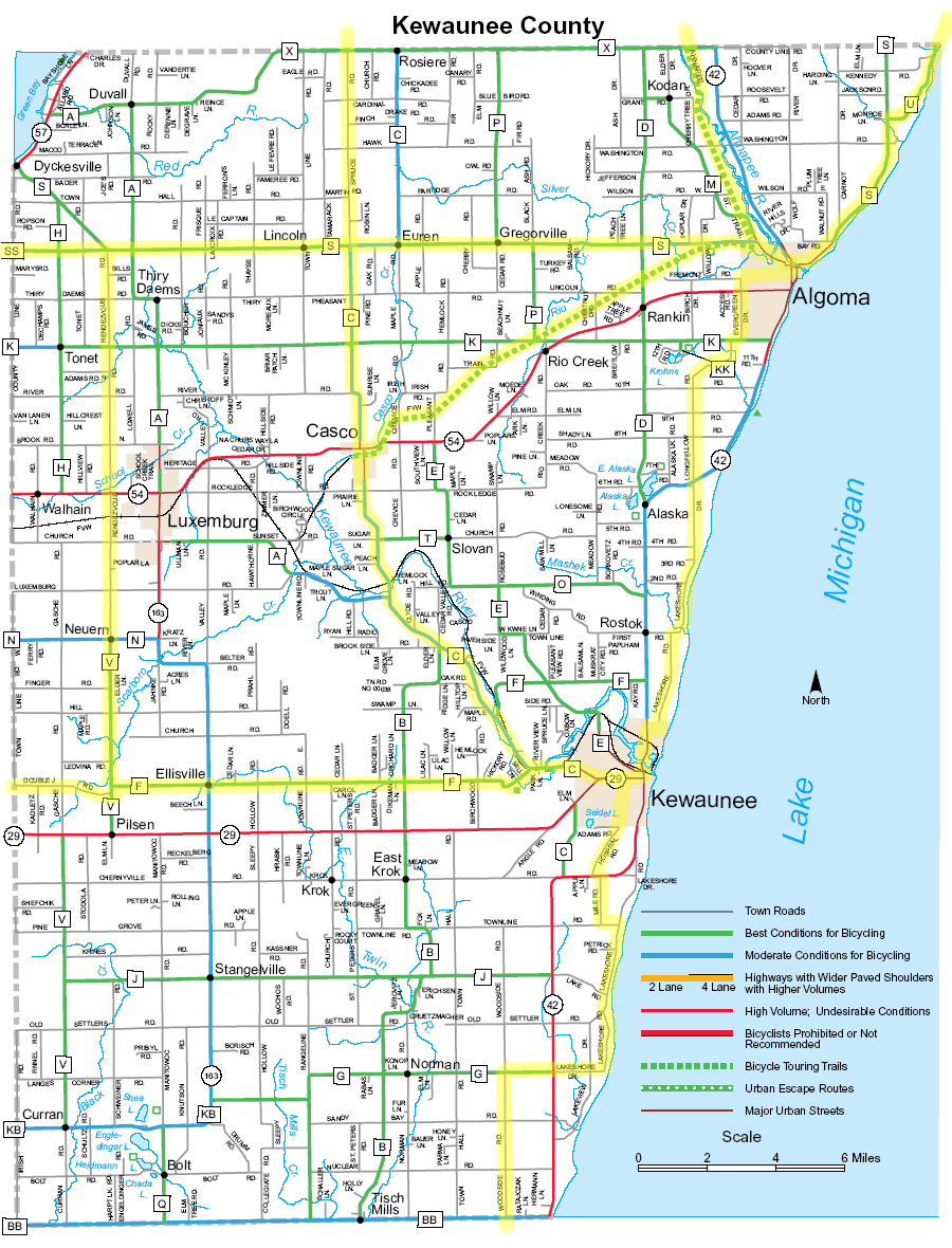
From the Manitowoc lake front, follow the Mariner's Trail along the Lake Michigan shoreline to Two Rivers.
Once in Two Rivers, go north on Washington, east on 22nd, and north on Jackson. Turn west on 30th which becomes Riverview Dr. Continue northwest on Riverview until it ends at county W. Go right (north east) on W and left (north west) on Tannery Rd. Turn east on Zander Rd and north on Nero Rd/Woodside Rd. Turn east on county G which, after crossing highway G becomes Lakeshore Rd and follows Lake Michigan most of the way to Kewaunee.
Between Two Rivers and Lakeshore Rd, most of the route described above is on straight roads through farming country. A more interesting, but longer, route can be had by following signs for the Rawley Point Trail and riding this unpaved path to and through Point Beach State Forest. You can follow this path to its end at a beach at the north end of the forest, but then you will have to backtrack to pick up the road north. Instead you can leave the trail on the park road and jog left to pick up county V which you will follow north and then west. Go north on Lakeshore Rd and then west on Nuclear Rd. If Lakeshore Rd is open past the Point Beach Nuclear Plant turn north on it; otherwise continue west on Nuclear to Tannery Rd and continue north as described in the previous paragraph. Assuming Lakeshore Rd is open past the nuclear power station, the next issue is whether to take it to its junction with highway 42. Since highway 42 is one of the main routes to Door County, it can be very busy during summer weekends and has skimpy shoulders. At those times, at least I would take Zander Rd west to Nero Rd and follow it north as described in the paragraph above. At other times I likely would continue on Lakeshore to its junction with 42 and continue on 42 to Lakeview Rd, go right on Lakeview and then right again on Lakeshore Rd.
Lakeshore Rd runs along Lake Michigan, joining highway 42 a couple of miles south of Kewaunee. This is the most direct route, assuming traffic on 42 is reasonable. To avoid this stretch, go west on Townline Rd, north on Mile Rd, jog west on 42, north on Hospital Rd, and then east into Kewaunee.
Leave Kewaunee on 42 going north and take the second right to get on Lakeshore Dr. Continue north across highway 42 to Longfellow Rd. Go east on county K, north on Evergreen Dr, and then east into Algoma.
|
|
|
|
|
|
|
|
|
|
|
|
|
|
|
|
|
|
|
|
Algoma to Sturgeon Bay
From downtown Algoma follow westbound county S to the Ahnapee Trail. Take the right fork to Sturgeon Bay. In Sturgeon Bay, cross the old bridge into downtown.
If you prefer to travel by paved road take county S in the northeast direction. The first part follows the lake; the rest is straight and crosses farm country. If you wish to see more of the lake, take a right a county U. It is a bit longer but more scenic.
|
|
|
|
|
|
Sturgeon Bay to Egg Harbor and Fish Creek 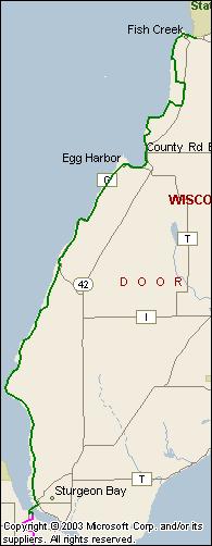
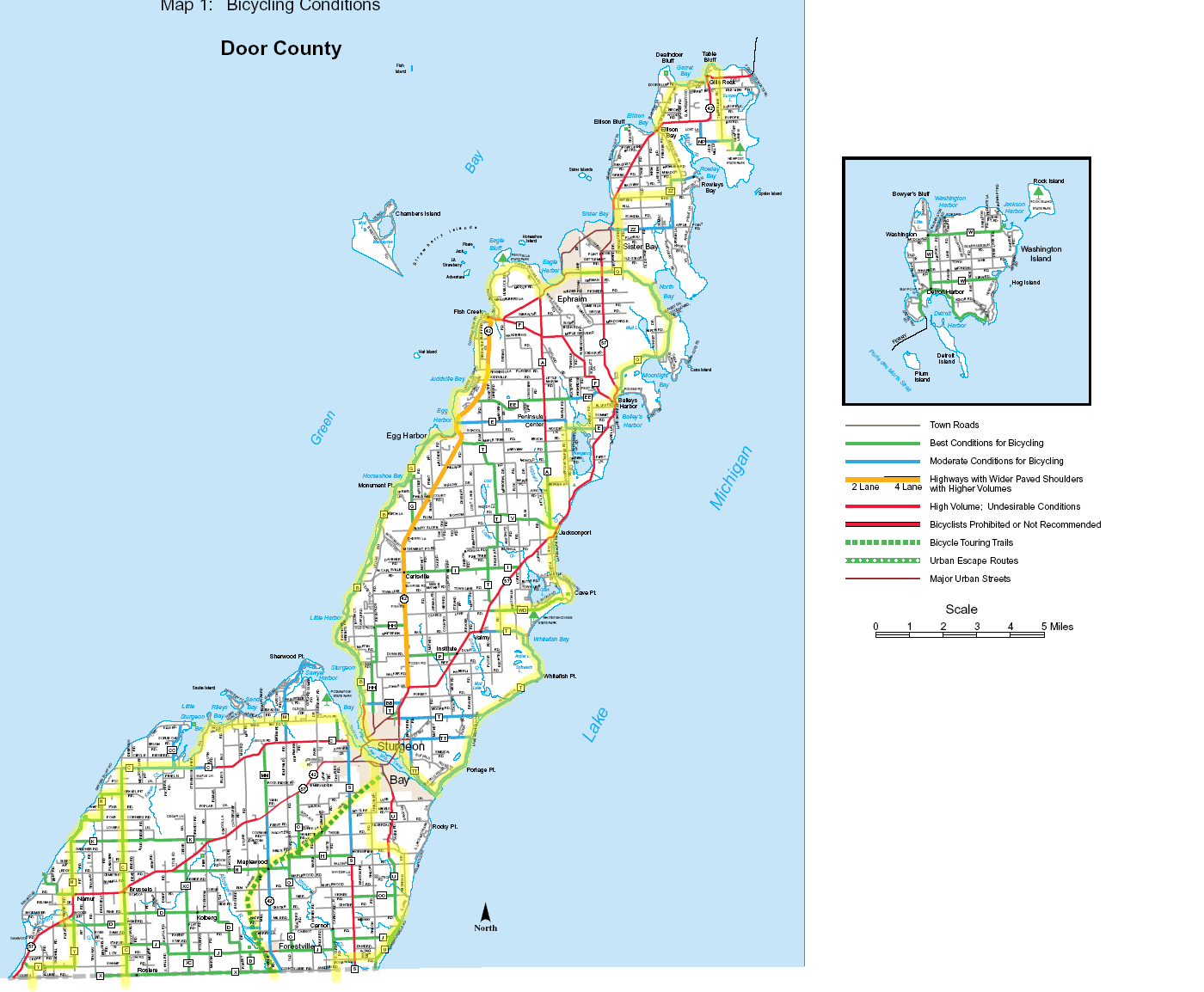
In Sturgeon Bay, turn northwest onto 3rd Street, which becomes county B. County B follows the strip of land between Green Bay and the bluff, until it intersects coutnty G. Continue north on County G to Egg Harbor.
In Egg Harbor, go left one block to the dock and White Cliff Road. Follow White Cliff Road north until it ends at Juddville Rd. Go east on Juddville, north on Highway 42 (wide shoulder), west on Peninsula Players Rd., and north along Green Bay to Fish Creek.
|
|
|
|
|
|
|
 |
|
|
|
|
|
|
|
|
|
|