Wisconsin Bicycle Routes |
|||
|
The Wisconsin Bikeway: East Bound Route
|
|||
|
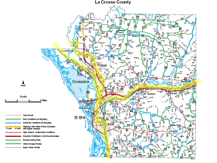
These are cue sheets showing the route of the Wisconsin Bikeway from La Crosse to Kenosha, Racine, and Milwaukee. They are taken from the Wisconsin Bikeway Map and Guide. I have included some notes (shown in italics) on what has changed since. I should caution that the names of roads in rural areas often seem to be in flux, with one name used at one intersection, another at the next intersection, and a third on the map. Before attempting these routes, I would purchase the southern section of the Wisconsin Bike Map and the Milwaukee and Southeast Wisconsin map for travel in Walworth or Waukesha county and points east. LA CROSSE TO SPARTAThis section of the bikeway was laid out before the La Crosse River State Trail was opened. The roads described below make for very pleasant biking and are a nice complement to the trail. See also the section on the Winona-Milwaukee route. Click here for the LaCrosse County Map
|
|||
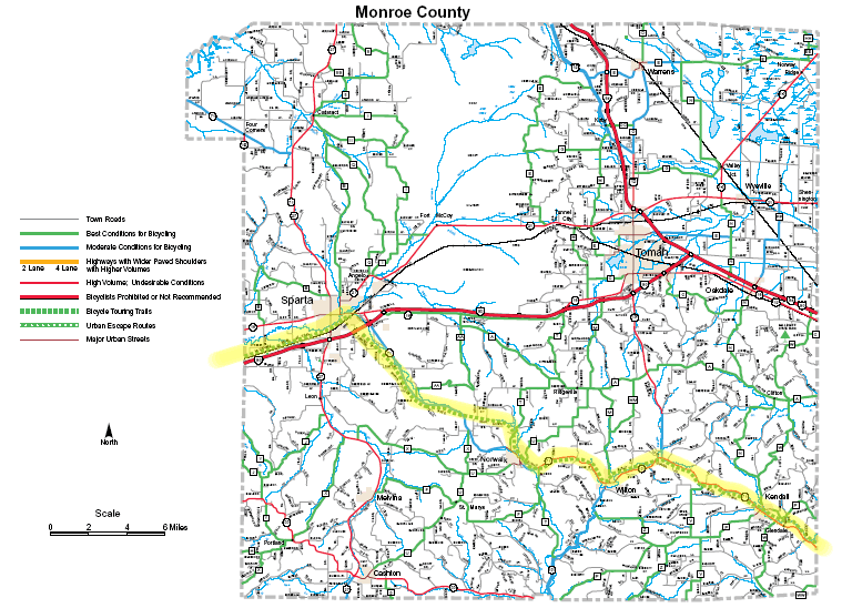
SPARTA TO ELROYClick here for the Monroe County Map
The Elroy-Sparta State Trail now joins the La Crosse River Trail in Sparta, crossing I-94 on a new bridge. ELROY TO REEDSBURGThis section of the bikeway was laid out before the "400" State Trail was opened, and offers an alternative route from Elroy to Reedsburg. The roads are scenic but quite hilly.
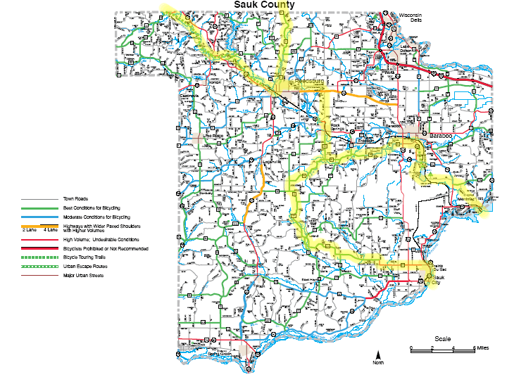
REEDSBURG TO PRAIRIE DU SACBetween Reedsburg and Prairie du Sac, the bikeway split. The original route went south from Reedsburg across the Baraboo Hills. The northern route went through Baraboo, Devil's Lake State Park, and crossed the Merrimack ferry. Our Winona-Milwaukee bicycle route follows the northern route between Reedsburg and the ferry. Original route
Northern route
PRAIRIE DU SAC TO BLUE MOUNDSAt Blue Mounds, the bikeway crosses the Military Ridge State Trail. To the west, this trail runs to Dodgeville; to the east to Madison.
BLUE MOUNDS TO NEW GLARUS
NEW GLARUS TO EVANSVILLE
EVANSVILLE TO MILTON
MILTON TO GENOA CITYThis and the following section described the southern route to Kenosha. These are followed by the route to Racine and Milwaukee.
GENOA CITY TO KENOSHAI would probably modify the following route. The route between Genoa City and the Fox River is unnecessarily circuitous. County C is quite nice on off hours but can get uncomfortably busy during the evening rush hour. Here is one suggestion (best with a map): Follow the route below onto County P, but then turn right on Main St into Twin Lakes. Take the bike trail to Bassett. Follow F to B. Go north to K, and take K into Kenosha.
MILTON TO MUKWONAGO
Traffic on Cty J and Cty ES can be quite heavy. I prefer to go north from Bluff Rd onto Shearer Rd and then right on Cty LO into Mukwonago. Leave Mukwonago, via the bike trail along Hwy 83. After crossing Interstate 43, the trail ends. Pick up Maple Ave. The next moves would depend on whether you wished to go to Racine or Milwaukee. MUKWONAGO TO RACINEFrom Maple, turn right on Craig and then take a series of local roads to get to Wind Lake (see the map for possible routes). Then take 7 mile road but follow county G, dropping to 6 mile and eventually 5 mile. This intersects with the Racine County bike path to Racine.
Seven Mile Road now dead ends after crossing Hwy 32, but one can pick up Middle St from 5 Mile Rd. See our Milwaukee-Chicago route dscription.
MUKWONAGO TO MILWAUKEE (WHITNALL PARK)Continue on Maple until its end at Forest Home. Go northeast on Forest Home Ave to Hwy 164 in Big Bend. Go south on 164 and east on Henneberry to Y, north on Y, then east of Woods Rd to 116th. Then go north on 116th, east on Janesville Rd, and continue on Forest Home Rd to the entrance to Whitnall Park.
Woods Rd crosses the Muskego Trail, which can be taken east to Milwaukee County, where it becomes the Franklin Trail. The south leg of the Franklin Trail connects to Swiss St and then Church St which connects to Drexel, the southern loop of the Oak Leaf Trail. The north leg of the Franklin Trail connects to Rawson Rd. North Cape and Forest Home can be quite busy with no shoulders. If not taking the Muskego Trail, an alternative is to turn left from Woods Rd onto 116th, then right on Grange. |
|||