|
Winona-Reedsburg
Winona, Minnesota, is on the Mississippi River directly across from Wisconsin. For those wishing to continue north to Minneapolis, Adventure Cycling's Section 7 of its Northern Tier route goes directly through Winona following the river on the Minnesota side. Bikeverywhere also sells a map for smart phones with a suggested route from the Twin Cities to Winona. On the Wisconsin side, the Wisconsin Department of Transportation publishes a very nice series of maps, Great River Road (Mississippi River Trail) Bicycle Map. It can be downloaded from the DOT website.
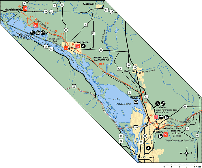
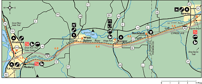
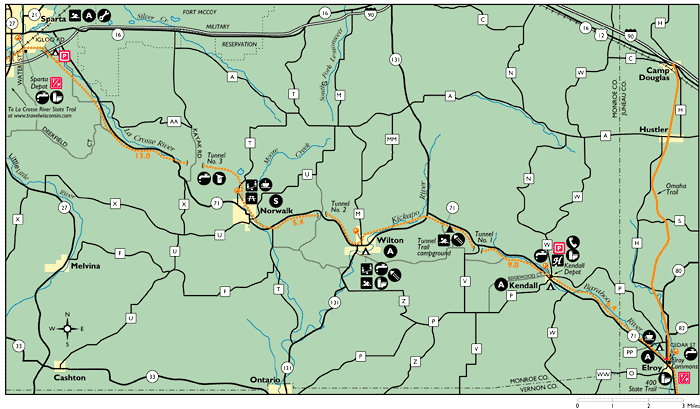
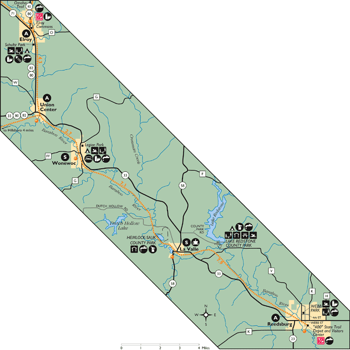
Between Winona and Reedsburg, there are four connected state bike trails that connect with each other: the Great River State Trail, LaCrosse River State Trail, Elroy-Sparta State Trail, and "400" State Trail. All were part of the Chicago and Northwestern major route between Chicago and Minneapolis. It was advertised as completing the route in 400 minutes, thus the name of the fourth trail. Click here for maps of the four trails.
From Winona, cross the Mississippi. Turn east (right) on highways 35/54 to the very small settlement of Marshland. At Marshland, on the south side of the highway is a small parking lot and the northern terminus of the Great River State Trail.
Follow this trail to Onalaska where it connects to the LaCrosse River State Trail. At the junction of the two trails, the Three Rivers Trail follows the LaCrosse River to its junction with the Mississippi River just north of Downtown LaCrosse (click here for a bike map of LaCrosse).
Continue east on this trail to Sparta and the connection to the Elroy-Sparta State Trail. Take this trail to Elroy, where it joins the "400" State Trail.
Follow the 400 to the old depot in Reedsburg.
|
|
Buffalo County Map
Trempeleau County Map
LaCrosse County Map
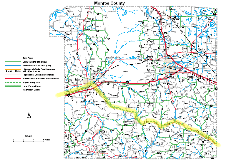
Monroe County Map
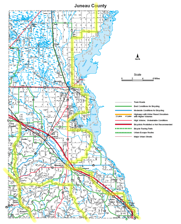
Juneau County Map
|
|
Reedsburg-Baraboo
From Reedsburg to Merrimac the route follows the Wisconsin Bikeway. Here starts the on-road portion of this trip. Starting from the Reedsburg depot:
- Take any city street north to 8th Street.
- Go east on 8th Street, which becomes Reedsburg Rd and county K.
- Turn south on Northwoods Dr (sometimes called Pine St).
- Jog briefly east on highway 23/33 (wide shoulder)
- Turn south on Abelman Rd (also called Chapel Rd) to its end at highway 136
- Turn left (east) on highway 136 through Rock Springs.
- Where 136 turns left, continue south on county DD
- Turn left (east) on county W (becomes South Blvd to Baraboo at the junction with Park Blvd (downtown Baraboo is to the left; Devil's Lake State Park to the right.
|
|
|
|
|
|
|
|
Baraboo-Lodi
At the junction of South and Park (county DL), turn left (south) onto the bike path next to DL Then:
- Immediately after crossing highway 136, turn right onto South Shore Rd. (This includes a very steep hill. To avoid this hill, stay on DL.)
- Turn left onto South Lake Rd to the south shore of Devil's Lake. Here is a map of Devil's Lake.
- Leave the park traveling west
- Turn right on highway 113
- Immediately turn left on DL
- Turn right on Marsh Rd to the free Merrimac Ferry across the Wisconsin River, The ferry normally operates from April 15 through November 30.
- After crossing the river, turn right on highway 188.
- Turn left (east on county V
- Continue on J to Lodi
- Turn right on highway 113 into downtown Lodi
|
|
|
|
|
Lodi-Madison
From Lodi
- Go west on Highway 60 (Water St.)
- Turn left (south) on Riddle Rd (becomes Springfield-Lodi Rd
- Turn right at Black Hill Rd to stay on Springfield-Lodi Rd
- Turn left (south east) at Latham Rd to stay on Springfield-Lodi Rd
- Continue to the intersection with US 12.
- Follow the bike path along US 12 to the Pheasant Creek Trail in Middleton.
- Take the Pheasant Creek Trail east, but get off at Parmenter St.
- Take Parmenter south to Hubbard.
- Follow Hubbard east until it ends at Old Middleton (Elmwood).
- Go southeast on Old Middleton.
- At EuClaire Ave, pick up a marked Madison bike trail leading east parallel to the railroad tracks. A mix of trails and streets leads to the huge University of Wisconsin campus.
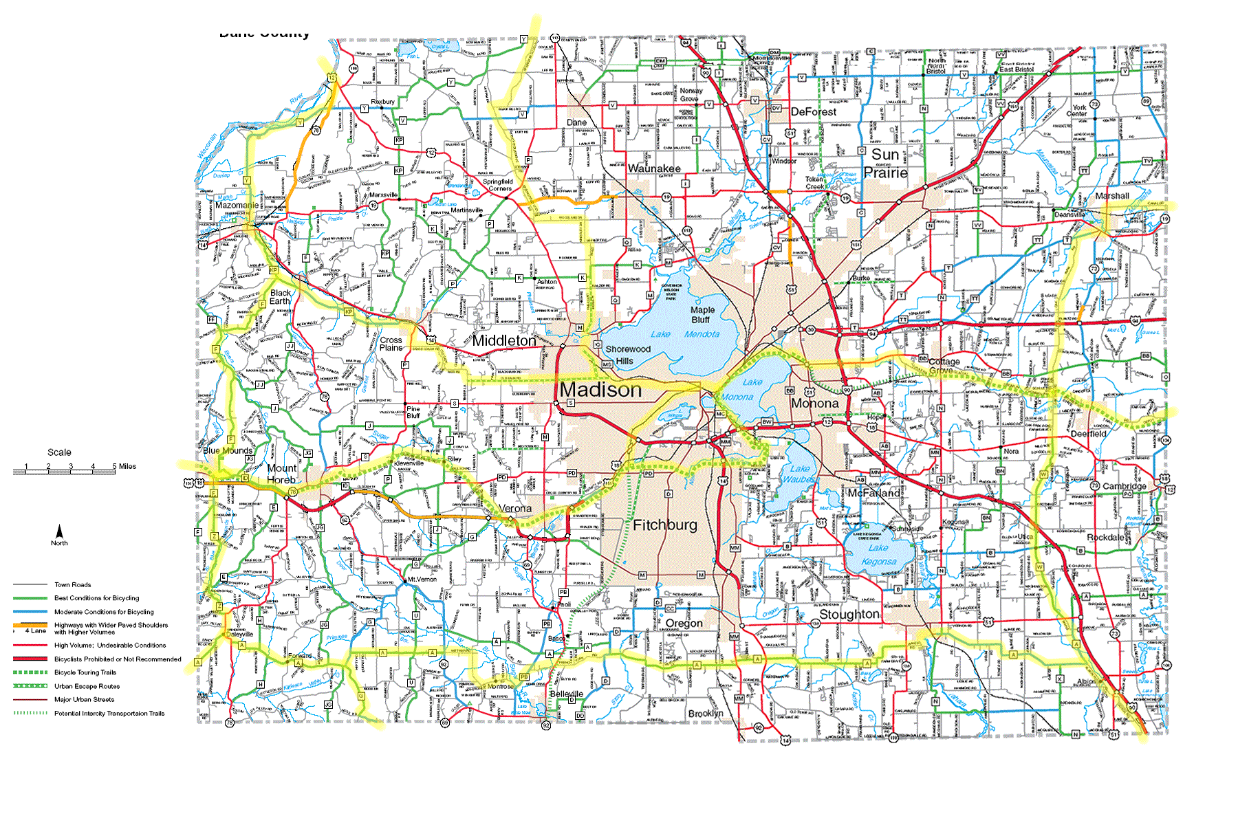
There is also a Madison bike map available free from local bike stores, but, in my experience, stores often run out. Dane County also has a map, but it has not been updated in some time.
|
|
|
|
|
Madison-Waukesha
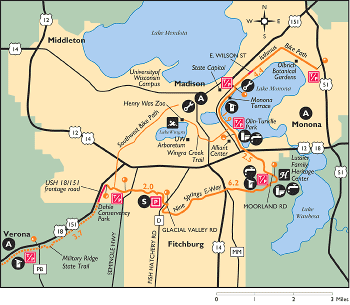
From the university, go east on University Ave, then south on Mills St to the Southwest Bike Path. Follow this path east until it ends. Take the Isthmus bikeway north east and then south east to its end at Cottage Grove Ave. Go east on Cottage Grove Ave (county BB), south east on Vilas Rd (not to be confused with Vilas Hope Rd), and east on Clark Rd to Cottage Grove. Click here for a map (pdf) showing these connections.
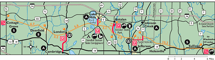
From Cottage Grove to Waukesha, follow the Glacial Drumlin State Trail. (West map and east map). The trail is unpaved from Cottage Grove to Dousman. It is paved between Dousman and Waukesha. Bikeverywhere's Milwaukee and Southeastern Wisconsin bike map covers the route between Dousman and Lake Michigan.
|
|
|
|
|
Waukesha-Milwaukee
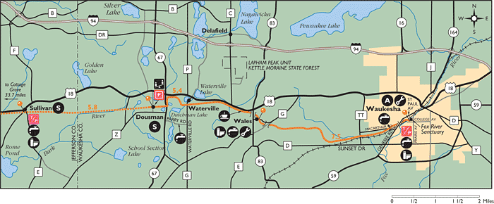
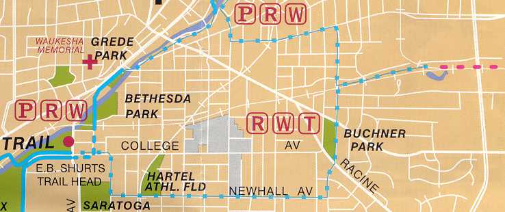
Between the end of the Glacial Drumlin State Trail on the west side of Waukesha and the New Berlin Trail on the east side, the bicyclist must traverse the somewhat confusing streets of Waukesha. Several years ago, Waukesha placed directional signs but they have faded and some have disappeared. Here is a map showing the connection between the two routes through Waukesha.
The paved New Berlin Trail runs from the eastern edge of Waukesha to Greenfield Park in Milwaukee County. Waukesha County no longer has trail maps on its web site, but the trail is shown on the Milwaukee and Southeast Wisconsin map. Traffic on the cross streets can be heavy.
At Greenfield Park, the route joins the Milwaukee County Oak Leaf Trail (The Winter 2020 Rails to Trails magazine has a cover article on this trail). The fastest route to Lake Michigan and downtown Milwaukee makes use of the Hank Aaron State Trail (HAST). To get to the HAST, go north on the Oak Leaf Trail. Just south of Blue Mound Road take a right onto the HAST.
At 6th street, go south to the spiral ramp leading off the bridge. There are blue signs that direct you to Lake Shore State Park. Following these signs leads to the park, the Summerfest grounds, Discovery World, and the Milwaukee Art Museum.
If continuing via the ferry to Michigan, go south at 2nd St, rather than north, until it ends at Maple St. Go east two blocks on Maple to its end at Kinnickinnic. Go south on Kinnickinnic and veer left on Bay St until its end at Russell. Go east on Russell until its end and then north to the ferry terminal.
|
|
|
|
|
|
 |
|
|
|
|
|